Words by: Nathan Ray Photos by: Tz Ting, Taiwan Scene, Andrew Haimerl, Young Chen, Gao Zanxian, Fion
Logo by: Geotechnical Engineering Office, Public Works Department, Taipei City Government
Taipei is a striking juxtaposition of human achievement and natural wonder. On one hand, you have the glistening, high-tech edifice of Taipei 101, and on the other, wild, untamed jungles. No matter where you are within the city, nature always lies within reach.
Hidden within this seemingly impenetrable wilderness that encircles Taipei are sights and secrets that are ripe to quell the wanderlust of city-bound souls.
In 2018, the Taipei City Government announced the opening of the Taipei Grand Trail (台北大縱走), an amalgamation of a massive, pre-existing network of mountain trails. Spanning a total of 92km, it reaches from the heights of Yangmingshan, or Mt. Yangming, in the north, wraps around the ridges of Neihu (內湖) in the east, then snakes all the way down to Maokong (貓空) in the south.
Composed of seven individual sections that each takes an average of seven hours to complete. Every section is easily accessible via public transport so it is entirely possible to complete one section at a time. Other than the distance, the trail climbs to an altitude of 1,120 meters at Mt. Qixing (七星山) Main Peak.
As a special bonus for dedicated hikers, the Geotechnical Engineering Office, Public Works Department, Taipei City Government (台北市政府工務局大地工程處) is offering a commemorative towel for those who complete the trail before December 31, 2021. Hikers must take photos of themselves with all of the 12 commemorative posts that are strategically placed along the way. The posts are a small plaque with a Chinese character written on the top. Signposts have also been erected along the entirety of the Grand Trail to guide hikers along their way. A hard copy of the map can be collected from the office during business hours.
SECTION 1: GUANDU ➞ ERZIPING
Section 1 of the Taipei Grand Trail begins in the northern district of Beitou. It is a hill climb from down in the city up to the Datun Saddle (大屯山鞍部) on Yangmingshan. It is approximately 10 kilometers in length and takes about seven to eight hours to complete. The beginning of the Grand Trail is marked at the intersection of Xueyuan Road (學園路) and Zhongyang North Road Section 4 (中央北路四段), a few minutes on foot from MRT Guandu Station (捷運關渡站). From there, it’s a couple kilometers through the campus of Taipei National University of the Arts (台北藝術大學) to reach the Mt. Zhongyi Trailhead (忠義山步道口). The ascent begins and the scenery transforms from the concrete jungle into a scene from Jurassic Park.
The main highlight about halfway up is Qingtian Temple (清天宮) in the Zhongjingque (中菁礐), a quaint mountainside village. This is but one of many temples that you will find along the Grand Trail. Then it’s a short trek up through the forest until you reach the highest point of Section 1, Miantian Ping (面天坪), at 815 meters above sea level.
This is the end of Section 1; you can either choose to continue on to Section 2 or leave via the Erziping Trail (二子坪步道) and catch Bus 108 back down the mountain.
On the greenery way from Qingtian Temple to Erziping, you can also walk up to the hills such as Mt. Miantian (面天山) to get a magnificent view of the Taipei.
Section 1 serves as a good primer for what to expect when embarking upon the Grand Trail.
**Please note identification is required to enter universtiy grounds due to COVID-19 preventative measures. (updated by March 2021)
SECTION 2: ERZIPING ➞ MT. DATUN ➞ XIAOYOUKENG
The altitude starts to climb with the second section of the Grand Trail where several peaks await, making it and the next section the most challenging stretch of the whole Grand Trail.
Section 2 is approximately 9 kilometers in length and takes an average of six to seven hours to complete. It can be started by continuing from Section 1, or by catching Bus 108 to Erziping Tourist Service Station and walking south via the Erziping Trail to Miantian Ping.
If you choose the latter, you will pass through the Erziping Recreation Area, a serene, grassy rest stop.
Venturing forth from Miantian Ping, you will begin to ascend Mt. Datun Western Peak. Immediately this climb becomes more strenuous as the sealed path gives way to craggy embankments of tree roots and rocks. If it has rained in previous days, expect it to be muddy, slippery and difficult to pass. Hiking poles or walking sticks gathered from nearby can be extremely useful. There are permanently fixed ropes that can be used to help you up. Both the Western and Southern Peaks of Mt. Datun are similar in difficulty and only 600 meters apart. They are rocky, windswept outcrops that arise from the damp forest below. The view is definitely worth the effort if the weather is favorable.
Once you pass Mt. Datun Main Peak, the next popular stop is Zhuzihu, famed for its fields of calla lilies, hydrangeas and the abundance of restaurants sitting in their midst. If the lilies are in bloom, you can expect scores of people swarming about, photographing the ephemeral sea of white. Gazing up on a clear day, you can spot the smoking Xiaoyoukeng (小油坑) fumarole where Section 2 terminates. From the Xiaoyoukeng Tourist Service Station you can catch Bus 108 to Yangmingshan Bus Terminal or continue on to Section 3.
**For Sections 2 and 3, please note that weather conditions can be much more volatile and potentially dangerous at higher altitudes, so plan your hike accordingly.
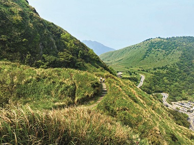
SECTION 3: XIAOYOUKENG ➞ MT. QIXING ➞QINGTIANGANG GRASSLAND ➞ FENGGUIKOU
With a length of about 14 kilometers and an estimated walking time of seven to eight hours, Section 3 begins from Xiaoyoukeng, reaches the highest peaks of Taipei, then dips down to Fengguikou (風櫃口), east of Yangmingshan.
It starts strong at Xiaoyoukeng, the site of smoking fumaroles emitting volcanic gases into the air. The strong smell of sulfur is a sobering reminder that you are in fact standing on an active volcano. Obey the warning signs and keep your distance.
Pressing on, you will reach Mt. Qixing Main and Eastern Peaks. Blessed with a stunning 360-degree view of Taipei and the north coast, these are the crown jewels of the Taipei Grand Trail. With an elevation of 1,120m above sea level, it is the highest point in Taipei. If it is a misty day, the ambience evokes images of Tolkien’s fantasies.
Descending from the heavens, the next attractions are the Qingtiangang Grassland (擎天崗) and Mt. Shiti (石梯嶺), which are home to a herd of water buffalo. They are often seen grazing peacefully in the grasslands, a surreal meadow that unfurls from within the densely forested slopes of Mt. Shiti. Even though the buffalo are typically passive creatures, they are still wild animals, so exercise caution.
Another popular stop along this wildly diverse trail is the Japanese Cedar forest just before Mt. Ding (頂山). It was part of a reforestation initiative led by the then Japanese government in the 1920s, an intriguing remnant of Taiwan’s turbulent history. Beyond the cedars is Mt. Ding and the way to Fengguikou. The stop for the Bus S1 (小1) is about 1 kilometer away, or you can continue along the Fengguikou Trail to Section 4.
SECTION 4: FENGGUIKOU ➞ BAISHIHU ➞DAHU PARK
Beginning in Fengguikou, Section 4 is a 16-kilometer stretch rambling down the hills to Dahu Park (大湖公園) in Neihu. The estimated completion time is from six to seven hours. The first several kilometers that pass Mt. Meihua (梅花山) and Mt. Bishan (碧山) are worn dirt paths that penetrate the thick Taiwanese jungle. Many seek respite at One Heart Pool (同心池), a peaceful lakeside stopover.
Not far away is the hilltop community of Baishihu (白石湖), its collection of organic strawberry farms and the 116-meter suspension bridge symbolizing a great dragon soaring across the valley. On the other side is Bishanyan (碧山巖) and the giant Bishan Temple (碧山 巖開漳聖王廟), which possesses a magnificent panoramic view of Taipei from the north. Right behind the temple is Mt. Zhongyong (忠勇山), which connects with Section 5.
Journeying back down through the forest feels almost like a page from The Lost World. Another popular rest stop is Yuanjue Temple Waterfall (圓覺寺瀑布), a spacious oasis hidden below Yuanjue Temple (圓覺寺). 06 The trail and the mountain stream both wind down to the Dagou Creek Water Park (大溝溪親水公園) close to MRT Dahu Park Station (捷運大湖公園站). The grassy lowlands are perfect for family picnics.
SECTION 5: DAHU PARK ➞ JIANTAN
The Jiantan Branch Line (劍潭支線), or Section 5, is a 13-kilometer trail that runs along the lower ridgeline between MRT Jiantan Station (捷運劍潭站) in Shilin (士林) and Bishan Temple in Neihu, where the path connects with Section 4. This route takes about six to seven hours to complete. It is an approachable, low-altitude hike that offers close-up views of the city.
If you choose to begin from Dahu Park, you can either hike up to the Bishan Temple or take Bus S2 (小2) from MRT Neihu Station (捷運內湖站). Venturing from Mt. Zhongyong, you will make your way through a mix of bush trails and mountain backroads. Much of the stone trail allows for an easy stroll through the bamboo forests that are iconic in East Asia.
Beyond Mt. Wenjian (文間山), by far the most popular stop on this trail is the Old Place Viewing Platform (老地方觀景平台) that faces Taipei Songshan Airport (台北松山機場), from there you also see Dajia Riverside Park (大佳河濱公園) and Taipei 101. Many photographers gather here to photograph the spectacle of planes taking flight.
There are other perfect vantage points that are less crowded along the Mt. Jiantan Trail (劍潭山步道). On the way you will find some military ruins such as sentry posts and old dorm houses. If you come in the afternoon, it is also a great sunset spot.
Then you can take the way down to Zhongshan North Road (中山北路) and MRT Jiantan Station.
SECTION 6: CHINA UNIVERSITY OF SCIENCE AND TECHNOLOGY ➞ MT. JIUWU ➞ MT. MUZHI ➞FUYANG ECO PARK
The entrance to Section 6 is tucked away behind the China University of Science and Technology (中華科技 大學). You can reach the university by taking Bus 620, amongst others, that run from MRT Nangang Exhibition Center Station (捷運南港展覽館站).
This is the most difficult section in the southern half of the Grand Trail. It’s 12 kilometers in length and takes about five to six hours to complete. What makes this particular section more difficult is the peak elevation of 375 meters at Mt. Jiuwu (九五峯).
Due to the steep climb and the trail’s proximity to the city, the views are the greatest seen from the southern ranges. Mt. Muzhi (拇指山) is the definite pinnacle of this trail. It’s a narrow, rocky outcrop that protrudes from the dense forest below. Once you scale the ropes to get to the top, you are rewarded with an unobstructed 360-degree view of Taipei. With Taipei 101 ahead, and Muzha (木柵) behind, there is nowhere else quite like it. Just below the peak is the Horseshoe Platform (馬蹄形平台), which is the perfect place for lunch with a superb view.
The descent is steep, so tread carefully. Once Anlu Temple (安祿宮) is reached, the trail splits with one direction continuing to Section 7 and the other connecting to the small Fuyang Branch Line (富陽支線). The small stretch that links Mt. Jungong (軍功山), Mt. Zhongpu (中埔山) and Mt. Fuzhou (福州山) is mostly a dirt trail trekking through the bush. Section 6 terminates in the Fuyang Eco Park (富陽生態公園), close to MRT Linguang Station (捷運麟光站).
SECTION 7: NATIONAL CHENGCHI UNIVERSITY ➞ ZHINAN TEMPLE TRIAL
➞ MAOKONG
Section 7 is approximately 18 kilometers in length and takes an average of six to seven hours to complete. The trail can be continued directly from the Fuyang Branch Line in Section 6 by catching Bus 282 from Heping East Road Section 4 (和平東路四段) to National Chengchi University (國立政治大學). From there the entrance to the Zhinan Temple Trail (指南宮步道) can be found tucked away in a quiet neighborhood beside the university.
The final section of the Taipei Grand Trail is easy to manage due to the lower elevation and much of the trail follows the roads through Maokong. The first stretch leading up to Zhinan Temple is ornamented with stone Japanese lanterns and rest stops. The Zhinan Temple itself provides an excellent view of the southern hills of Taipei.
Not far behind it is the Maokong Gondola Station and the Green Light Platform (綠光平台) where you can watch as the cable cars quickly dip down into the valley below before zipping up to the final stop in Maokong. As you venture further into the forest, you can find the waterfall and the eponymous Maokong Potholes (貓空壺穴) further upstream.
Besides its namesake, Maokong is known for its many tea plantations dotting the hills which can be seen on the Taipei Tea Promotion Center for TieGuanyin Tea and Baozhong Tea (台北市鐵觀音包種茶研發推廣中心) and Camphor Tree Trails (樟樹步道). Camphor harvesting in Taiwan dates back to the Japanese colonial era, yet another reminder of Taiwan’s tempestuous history. The walk through the bustling tourist area of Maokong is easygoing, and there are numerous eateries with panoramic views of the slopes. There are also many outlets offering local snacks like tea-flavored ice cream.
The Color Cloud Pavilion (彩雲亭) is the last attraction as the trail winds back down the mountain, via the Feilong Trail (飛龍步道), to finally terminate within the grounds of National Chengchi University.
The Taipei Grand Trail is an incredible showcase of the natural splendor of Taiwan and the dynamic and thriving metropolis of Taipei. It is a gorgeous feast for the eyes and an invigorating challenge for the legs. It is such an ineffable and engaging way to travel around a modern city and it proves how unique, and how grand, Taipei genuinely is.
For more information on Taipei Grand Trail: gisweb.taipei.gov.tw/release/


沒有留言:
張貼留言